Comprehensive Assessment of Water Supply in Maryland |

|
Comprehensive Assessment of Water Supply in Maryland |
|
Fractured Rock: Current Activities |
||
Science Plan for the Maryland Fractured Rock Water-Supply Study |
||
|
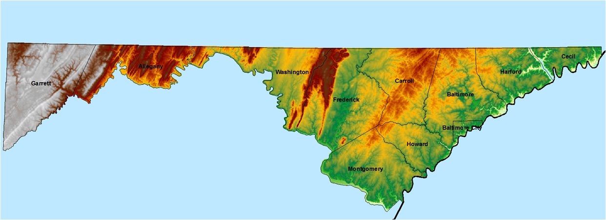
The U.S. Geological Survey (USGS), Maryland Department of the Environment (MDE), Maryland Geological Survey (MGS), and Maryland Department of Natural Resources Monitoring and Non-Tidal Assessment (DNR MANTA) are currently drafting a science plan for the Fractured Rock Water-Supply study. The purpose of this document is to explain the key water-resource issues facing the Fractured Rock areas of Maryland, describe the proposed study activities designed to address those issues, and define the resources required to implement the study. |
|
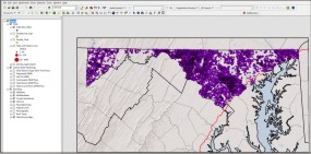
Development of the Fractured Rock Aquifer Information System (FRAIS) |
||
.jpg) |
USGS and MGS staff are coordinating with MDE and DNR MANTA to build a Geographic Information System (GIS) database or geodatabase, as a tool for permitters and researchers to visualize and spatially analyze relevant data for each users area of responsibility and expertise. Currently, the FRAIS is being developed in a pilot study area in the Frederick Valley, with plans to expand to other areas west of the Fall Line.
Fractured Rock Aquifer Information System |
|
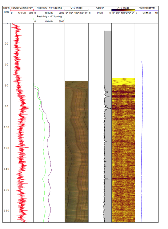
Geophysical Logging of Groundwater Supply Wells |
||
USGS and MDE staff are coordinating with county and municipal water managers to geophysically log production wells in Frederick, Carroll, and Montgomery Counties. The goal of this pilot logging effort is to better understand the position and distribution of fractures intersecting highly productive boreholes in Fractured Rock. Logs to be run are: 3-arm caliper, gamma, fluid resistivity, fluid temperature, optical televiewer (OTV), acoustic televiewer (ATV), and electromagnetic flow meter. The final log files will be compiled and incorporated into the FRAIS. |
 |
|
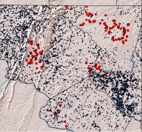
Factors Affecting Well Yields |
||
MGS and USGS staff are compiling well data in Frederick, Carroll, and Montgomery Counties into the USGS Ground Water Site Inventory (GWSI) database, and the Fractured Rock Aquifer Information System. The data are being used to analyze factors which influence well yields, such as topography, lithology, and depth to bedrock. The purpose of this investigation is to help water users identify well locations where groundwater may be available for withdrawal. MGS staff are currently drafting a report describing this analysis within the pilot study area.
|
 |
|
Hydrogeologic Framework |
||
| USGS staff are employing statistical methods and GIS techniques to delineate areas of similar hydrogeologic character in the 8 digit hydrologic units which flow through Maryland west of the Fall Line. The goal of this effort is to provide a hydrogeologic framework for resource managers and researchers within the FRAIS. Preliminary results match well with previous regional descriptions of hydrogeology in Maryland. | 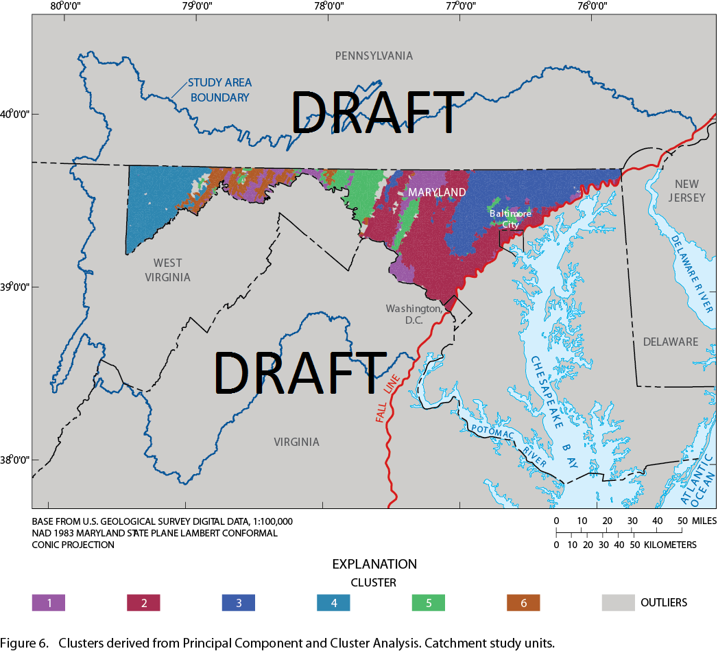 |
|
Index Gages and Developing Methods to Estimate Daily Stream Flow at Ungaged Sites |
||
| USGS staff are applying statistical and geostatistical techniques to build a decision-support tool to select the most correlated reference stream gage record when assessing water allocation permits. The data from these Index Gages will be the basis for estimating daily flow at ungaged sites in a subsequent phase of the study. Estimates of daily flow will then be used to generate selected streamflow statistics used in conjunction with a site-specific biological database compiled by DNR MANTA and water-use information from MDE to perform a hydroecological assessment of aquatic habitats in Maryland streams.
|
||
Hydroecological Assessment of Aquatic Habitats |
||
Meeting the demands of water for human consumption while sustaining the health of aquatic ecosystems is a growing problem world-wide and the issue is no stranger to Maryland. Severe droughts and water-use restrictions in recent years have highlighted this issue. One finding of the the Advisory Committee on the Management and Protection of the State's Water Resources was that watersheds in the Fractured Rock portion of the state may not provide adequate amounts of water for human consumption without causing adverse impacts to stream ecology. The Maryland Department of Natural Resources’ (DNR) Monitoring and Non-Tidal Assessment Division (MANTA), through its nationally recognized Maryland Biological Stream Survey, is conducting investigations into the biological health of Maryland’s streams that are affected by water withdrawal and the ecological response to hydrologic alteration. Ongoing activities of this project include: 1. a review of literature on flow-ecology relationships and biological response to water withdrawals and flow alteration; 2. an examination of the response of biota to coincident measures of stream flow, with particular emphasis on investigating potential impacts of water withdrawals; and 3. the establishment of flow-ecology research watersheds which may incur impacts due to water withdrawals. For more information on these studies, please visit the Maryland Biological Stream Survey's Environmental Flows website. See also DNR MANTA Fact Sheets: |
 |
|