


Data
DATASET TITLE:
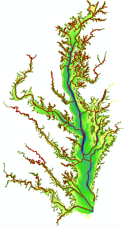
Deepest Chesapeake Bay Channels

A request was made in October 2006 for a map delineating the deepest parts of the Chesapeake Bay. These deep areas can be thought of as relict thalwegs of modern and ancient rivers in the Chesapeake Bay watershed.
Please note this GIS data contains only the channel traces, not the shoreline or shaded bathymetry shown in the thumbnail image on this page.
| Description | Polyline map tracing the deepest parts of the Chesapeake Bay and its tidal estuaries. Channels were digitized based on deepest contours, channel slope, channel width and bottom geomorphology. Contour data derived from NOAA/NOS 30 meter gridded DEM for Chesapeake Bay bathymetry |
|---|---|
| Purpose | The deepest parts of the Bay and its estuaries may represent a natural barrier to cross-channel sediment transport. This map was developed as a starting point to assist in modeling sediment transport in the Bay. |
| Custodian | Maryland Department of Natural Resources/Maryland Geological Survey |
| Contact | Robert D. Conkwright - (410) 554-5545; e-mail: [email protected] |
| Date | October 25, 2006 |
| Data Type | GIS binary data |
| Format | ESRI shapefile |
| Geographic Area | Maryland and Virginia Chesapeake Bay and tributaries roughly to tidal limits |
| Coordinate System | UTM Zone 18N, WGS 1984 (GCS WGS 1984), meters |
| Attributes | northing, easting, depth (meters) |
| Detailed metadata | Yes - included in Zipped file with data |
