 MGS
Home Page
MGS
Home Page Coastal & Estuarine Home Page
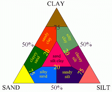 Based upon the proportions of sand-, silt- and clay-sized particles, the bottom
sediments were classified according to Shepard's diagram. This classification
system is the basis of the Md. Coastal
Bays sediment distribution map and the Chesapeake
Bay sediment distribution map (see maps legends). Shepard's diagram is an
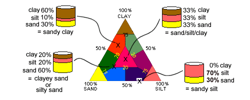
example of a ternary diagram - a device for graphing a three-component system
summing to 100%. In this case, the components are the percentages of sand, silt,
and clay comprising a sediment sample. Each sediment sample plots as a point within
or along the sides of the diagram, depending on its specific grain size composition.
A sample consisting entirely of one of the components, 100% sand, for example,
falls at the same-named apex. A sediment entirely lacking in one of the components
falls along the side of the triangle opposite that apex. The rest fall somewhere
in between.
Based upon the proportions of sand-, silt- and clay-sized particles, the bottom
sediments were classified according to Shepard's diagram. This classification
system is the basis of the Md. Coastal
Bays sediment distribution map and the Chesapeake
Bay sediment distribution map (see maps legends). Shepard's diagram is an
example of a ternary diagram - a device for graphing a three-component system
summing to 100%. In this case, the components are the percentages of sand, silt,
and clay comprising a sediment sample. Each sediment sample plots as a point within
or along the sides of the diagram, depending on its specific grain size composition.
A sample consisting entirely of one of the components, 100% sand, for example,
falls at the same-named apex. A sediment entirely lacking in one of the components
falls along the side of the triangle opposite that apex. The rest fall somewhere
in between.
To classify sediment samples, Shepard (1954) divided a ternary diagram into ten classes. Shepard's diagram follows the conventions of all ternary diagrams. For example, Shepard's "Clays" contain at least 75% clay-sized particles. "Silty Sands" and "Sandy Silts" contain no more than 20% clay-sized particles, and "Sand-Silt-Clays" contain at least 20% of each of the three components. The exact boundaries of each of the ten classes are described in the metadata for thedata set used to compile the sediment distribution map.
| NAVIGATE: | |
| MGS
Home Page |
Coastal & Estuarine Home Page |