Coastal & Estuarine Geology Program Navigation buttonsGeologic Map Legends
Eastern Piedmont Metasedimentary Rocks

The information contained on this page was adapted from Maryland Geological Survey's Geologic Map of Maryland (1968). This information reflects geologic interpretations from over 20 years ago and do not necessarily represent an accurate interpretation of currently accepted geologic theory. We present this information for historic purposes only. Do not use this information for anything other than illustrative purposes. When a corrected and updated geologic map of Maryland is available you will see a notification on our web site.

PLEASE NOTE:

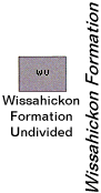
The designation "Wissahickon formation" is no longer used in Maryland. The legend presented here was reproduced from the 1968 Geologic Map of Maryland, but does not reflect current theory. The "Wissahickon' group has been broken up into various divisions by several authors. The nomenclature is somewhat confusing, and is summarized at the bottom of this page. Also, the rocks that were formerly included in the "Wissahickon" are probably Upper Cambrian or Lower Ordovician in age, and not Precambrian.

Peach Bottom Slate (Ordovician) Peach Bottom Slate
Hard, bluish-black graphic slate; thing beds of fine-grained black quartzite near base; apparent maximum thickness 1,000 feet.
Cardiff Metaconglomerate (Ordovician)
Cardiff Metaconglomerate
Silvery-gray, well foliated, micaceous quartz-pebble metaconglomerate and quartzite; apparent maximum thickness 700 feet.
Click here for a clarification of the Wissahickon Upper Pelitic Schist  (Late Precambrian ?) Upper Pelitic Schist
(Formerly mapped as albite facies of Wissahickon Formation.) Albite-chlorite- muscovite-quartz schist with sporadic thin beds of laminated micaceous quartzite; coarsens form west to east; primary sedimentary structures include normal bedding, graded bedding, and soft-sediment deformational structures; apparent thickness 14,000 feet.
Metagraywacke (Late Precambrian ?) Metagraywacke
(Formerly mapped as Peters Creek Formation.) Rhythmically interbedded chlorite-muscovite metagraywacke and fine-grained chlorite-muscovite schist; graded bedding locally preserved; thickness probably 2,000 to 3,000 feet.
Metaconglomerate  (Late Precambrian ?)

Metaconglomerate
Silvery-gray, well foliated, micaceous quartz-pebble metaconglomerate and quartzite; apparent maximum thickness about 1,200 feet at Deer Creek, Harford County.

Boulder Gneiss (Late Precambrian ?) Boulder Gneiss
(Formerly mapped as Sykesville and Laurel Formations.) Thick-bedded to massive, pebble- and boulder-bearing, arenaceous to pelitic metamorphic rock, typically a medium-grained, garnet-oligoclase-mica-quartz gneiss; locally an intensely foliated gneiss or schist; apparent thickness 15,000 feet.
Lower Pelitic Schist  (Late Precambrian ?) Lower Pelitic Schist
(Formerly mapped as oligoclase facies of Wissahickon Formation.) Medium- to coarse-grained biotite-oligoclase-muscovite-quartz schist with garnet, staurolite, and kyanite; fine- to medium-grained semipelitic schist; and fine-grained granular to weakly schistose psammitic granulite; psammitic beds increase upward; apparent thickness 5,500 feet or more.
Cockeysville Marble (Late Precambrian ?) Cockeysville Marble
Metadolomite, calc-schist, and calcite marble are predominant; calc-gneiss and calc-silicate marble widespread but minor; thickness about 750 feet.
Setters Formation (Late Precambrian ?) Setters Formation
Upper member: Feldspathic mica schist and mica gneiss; middle member: Impure quartzite interstratified with thin beds of mica schist; lower member: Medium-grained, feldspathic mica schist, locally granitized; total thickness 200 to 500 feet.
Baltimore Gneiss  (Precambrian) Baltimore Gneiss
Biotite-quartz-feldspar gneiss and biotite-hornblende gneiss; amphibolite widespread but subordinate; texturally varied; granitic gneiss, veined gneiss, augen gneiss, banded gneiss, and migmetite in places complexly intermingled; age 1,100 m.y.* by radiogenic dating. Layered paragneiss in Baltimore City southeast of Relay Quartz diorite.
HARFORD COUNTY
Stratigraphic relationships of lithofacies of Wissahickon Formation in Harford County (from Southwick and Owens).
Stratigraphic relationships of lithofacies of Wissahickon   (Late Precambrian ?)
     
Volcanic Complex of Cecil County  (Late Precambrian ?) Volcanic Complex of Cecil County
Metamorphosed andesitic and dacitic volcanic rocks (greenstone, greenschist, quartz amphibolite, and schistose felsite); amygdules and volcano-clastic textures locally preserved; thickness unknown.
James Run Formation  (Late Precambrian ?) James Run Formation
Thick bedded, light gray biotite-quartz-plagioclase gneiss with thin interbeds of quartz amphibolite; grades downward onto sharply layered, thin- to thick-bedded paragneiss composed of subequal amounts of biotite-quartz-plagioclase gneiss and quartz amphibolite; thickness unknown.
*Radiogenic date from Wetherill et al., 1966


SUMMARY OF NOMENCLATURE AND SUBDIVISION OF THE "WISSAHICKON" (1)

These rocks are now considered upper Cambrian to Lower Ordovician, not Precambrian

Harford County Geologic Map
(Southwick and Owens, 1968)
(Also see Southwick and Fisher, 1967)
Report of Investigations 27
Plate 2, generalized geologic map of Baltimore and Harford Counties (Crowley, 1976)
Report of Investigations 67
Plate 1a , inset map of the geology of the Delta Quad
(Muller, 1990)
Op Peach Bottom Slate pb Peach Bottom Slate pbsl Peach Bottom Slate
Oc Cardiff Metaconglomerate cc Cardiff Metaconglomerate pbcc Peach Bottom Cardiff Metaconglomerate
pCwu upper pelitic schist ps Prettyboy Schist pb Prettyboy Schist
py unnamed phyllite (2)
pg Pleasant Grove Schist pg Pleasant Grove phyllite and phyllitic schist
pCwg metagraywacke and fine-grained pelitic schist o Oella Formation or

Piney Run Formation

pc Peters Creek (3)
pCwc metaconglomerate

sy
Sykesville Formation rp Rocks Park metaconglomerate (4)
pCwb boulder gneiss, metagray-wacke dc Deer Creek Complex: schist, metagraywackes, and intrusives
pr Piney Run Schist (5)
pCwl lower pelitic schist   Loch Raven schist   (not recognized in Delta Quad)
pzm Muscovite quartz monzonite gneiss   glg granitic leucogneiss
pzb Baltimore gabbro bg Baltimore Mafic Complex Bel Air metagabbro bac Bel Air Complex metagabbro
pzug ultramafic and gabbroic rocks u undifferentiated allocthonous ultramafic rocks u/s ultramafic intrusive bodies (u) locally serpentinized (s)
pzum ultramafic rocks

(1) The term "Wissahickon" was first used by Bascom (1902) in Pennsylvania, then Mathews (1904) in Maryland. Southwick and Fisher (1967) recognized five formations within the Wissahickon: Lower Pelitic Schist, Boulder Gneiss, Metaconglomerate, Metagraywacke, and Upper Pelitic Schist. Crowley (1976) recognized six formations within the Wissahickon: Loch Raven Schist, Oella Formation, Piney Run Formation, Sykesville Formation, Pleasant Grove Schist, and Prettyboy Schist. The Pleasant Grove Formation, in particular, had previously been included in the Peters Creek Schist (Knopf and Jonas, 1923) or Peters Creek Formation (Knopf and Jonas, 1929b). Hopson (1964) considered the Peters Creek Formation to be a discontinuous turbidite facies within his Western Sequence of the Wissahickon (comparable to the upper pelitic schist and metagraywacke of Southwick and Fisher (1967).

(2) This unnamed phyllite was included as a "gray phyllite" on the first draft of the geologic map at 1:24,000 scale, but was omitted from a final draft at 1:24,000.

(3) On the earlier draft map, Muller showed the area of Peters Creek as Piney Run Formation

(4) Comparable to the Deer Creek quartzite of Leslie (1892, p. 130-132).

(5) On the inset map showing bedrock geology on Plate 1 of Report of Investigations No. 67, Muller shows the small area of Piney Run schist (pr) in the southwest part of the Delta 7.5-min. Quadrangle as Deer Creek Complex (dc) on an unpublished 1:100,000-scale map that was prepared at roughly the same time (1990). Muller's stratigraphic placement of this Piney Run is lower than that of Southwick and Fisher (1967) and Crowley (1976), presumably because Muller interprets it as part of an upthrust sheet.

References

Bascom, F., 1902, The geology of the crystalline rocks of Cecil County: Maryland Geological Survey, Cecil County Report, p. 83-148.

Crowley, W.P., 1976, The Geology of the Crystalline Rocks Near Baltimore and Its Bearing on the Evolution of the Eastern Maryland Piedmont: Maryland Geological Survey Report of Investigations No. 27, 39 p.

Higgins, M.W., 1972, Age, origin, regional relations, and nomenclature of the Glenarm Series, Central Appalachian Piedmont: a reinterpretation: Geol. Soc. America Bull., v. 83, p. 989-1026.

Hopson, C.A., 1964, The crystalline rocks of Howard and Montgomery counties, in The Geology of Howard and Montgomery Counties, Maryland: Maryland Geological Survey, p. 27-215.

Knopf, E.B., and Jonas, A.I., 1922, Stratigraphy of the crystalline schists of Pennsylvania and Maryland: Geol. Soc. America Bull., v. 33, p. 110.

_____, and _____, 1923, Stratigraphy of the crystalline schists of Pennsylvania and Maryland: Am. Jour. Sci., 5th ser., v. 5, p. 40-62.

_____, _____, 1929, Geology of the crystalline rocks, Baltimore County, in Baltimore County: Maryland Geological Survey, p. 97-129.

Leslie, J.P., 1892, A summary description of the geology of Pennsylvania: Pennsylvania Geological Survey, 2nd, Final Report, v. 3, 2588 p.

Mathews, E.B., 1904, The structure of the Piedmont plateau as shown in Maryland: Am. Jour. SCI, 4th ser., v. 17, p. 141-159.

Muller, P.D., 1990, Geologic map of the Delta 7.5-minute Quadrangle, Maryland and Pennsylvania: Maryland Geological Survey, unpublished file map, scale 1:24,000.

Southwick, D.L., 1969, Crystalline rocks, in Southwick, D.L. and Owens, JP, Geology of Harford County: Maryland Geological Survey, County Reports Series, p. 1-76.

Southwick, D.L., and Fisher, G.W., 1967, Revision of stratigraphic nomenclature of the Glenarm Series in Maryland: Maryland Geological Survey Report of Investigations No. 6, 19 p.

Southwick, D.L., and Owens, J.P, 1968, Geologic Map of Harford County: Maryland Geological Survey, County Geologic Map Series, scale 1:62,500.

Updated 9/14/00

| Return to previous page | Go to the Geologic Maps Home Page |
Jump to the Geologic Maps Home Page Return